abcdefghijk
-
Posts
8 -
Joined
-
Last visited
Content Type
Profiles
Forums
Events
Gallery
Everything posted by abcdefghijk
-
CAESAREA MAZACA (modern Kaisarieh) The chief town of a sanjak in the Angora vilayet of Asia Minor. Mazaca was the residence of the kings of Cappadocia, later called Eusebea (perhaps after Ariarathes Eusebes), and named Caesarea probably by Claudius. It stood on a low spur on the north side of Erjies Dagh (Mt. Argaeus). The site, now called Eski-shehr, shows only a few traces of the old town. It was taken by Tigranes anddestroyed by the Persian king Shapur (Sapor) I. after his defeat of Valerian in A.D. 260. At this time it is stated to have contained 400,000 inhabitants. In the 4th century Basil, when bishop, established an ecclesiastical centre on the plain, about 1 mile to the north-east, and this gradually supplanted the old town. A portion of Basil’s new city was surrounded with strong walls and turned into a fortress by Justinian; and within the walls, rebuilt in the 13th and 16th centuries, lies the greater part of Kaisarieh, at an altitude of 3500 ft. The town was captured by the Seljuk sultan, Alp Arslan, in 1064, and by the Mongols in 1243, before passing to the Osmanli Turks. Its geographical situation has made it a place of commercial importance throughout history. It lay on the ancient trade route from Sinope to the Euphrates, on the Persian Royal Road from Sardis to Susa, and on the great Roman highway from Ephesus to the East. It is still the most important trade centre in eastern Asia Minor. The town is noted for its fruit, especially its vines; and it exports tissues, carpets, hides, yellow berries and dried fruit, Kaisarieh is the headquarters of the American mission in Cappadocia, which has several churches and schools for boys and girls and does splendid medical work. It is the seat of a Greek bishop, an Armenian archbishop and a Roman Catholic bishop, and there is a Jesuit school. On the 30th of November 1895 there was a massacre of Armenians, in which several Gregorian priests and Protestant pastors lost their lives. The population, according to Cuinet, is 71,000 (of whom 26,000 are Christians). Sir C. Wilson gave it as 50,000 (23,000 Christians).
-
VAN Van occupies the site of Dhuspas, of which the native name was Biainas (Assyrian, Urardhu), the Byana of Ptolemy and the Ivan of Cedrenus, whence the modern Van. Dhuspas, the Thospia of Ptolemy, gave its name to the district of Thospitis, the modern Thosp. The Biainian dynasty, of which Sarduris I. (c. 833 B.C.) was the first king, died out with Sarduris II, who in 645 B.C. entered into an alliance with Assur-banipal. Inscriptions of nearly all the kings exist, and the various excavations at Toprak Kale show an advanced state of civilization and great technical skill (see illustrations in Maspero's Histoire ancienne, vol. iii, Les Empires). In the 6th century B.C. Van passed into the hands of the Persians, and shortly before it fell to Alexander the Great it was rebuilt, according to Armenian historians, by a native prince called Van. In 149 B.C. Valarsaces or Vaghar-shag, the first Armenian king of the Arsacidae, rebuilt the town, and a colony of Jews was settled in it by Tigranes (94-56 B.C.). In the middle of the 4th century A.D. it was taken by Sapor (Shapur) II, and became the capital of an autonomous province of the Sassanian Empire, until it fell into the hands of the Arabs (c. 640), under whom it regained its autonomy. About 908 the governor of Van or Vaspuragan was crowned king by the caliph Moktadir, and in 1021 his descendant Senekherim was persuaded by Basil II to exchange his kingdom for the viceroyalty of the Sebasteian theme. After having formed part of the possessions of the Seljuks, Mongols, Tatars and Persians, Van passed in 1514, after the defeat of Shah Ismail by Selim I. at the battle of Kalderan, to the Osmanlis, who only occupied the town in 1543. In 1636 it was taken by the Persians, but soon recovered. In 1845 the town was held for a time by the Kurd chief Khan Mahmud, who eventually surrendered and was exiled. The vilayet of Van lies along the Persian frontier between the vilayets of Erzerum and Mosul. The northern sanjak comprises open plateau country N. and E. of the lake (with a large Armenian agricultural population and Kurdish semi-nomad tribes occupied chiefly in cattle and sheep raising), also of several fertile districts along the south shore of the lake. The southern sanjak is entirely mountainous, little developed and having the tribes only partly under government control. This comprises most of the upper basin of the Great Zab, with the country of the Nestorian Christians and many districts inhabited by Kurdish tribes, some of them large nomad tribes who descend for the winter to the plains of the Tigris. The mineral wealth of the vilayet has never been fully explored, but is believed to be great. There are petroleum springs at Kordzot, deposits of lignite at Sivan and Nurduz, several hot springs at Zilan Deresi and Julamerk. Excellent tobacco is grown in Shemsdinan for export to Persia. The trade of Van has declined; European goods, with which the bazaars are fairly well supplied, come from Trebizond through Erzerum. There is a fair local trade in wheat and agricultural produce, also sheep and cattle, wool, hides and furs for export. A thick woollen cloth called shayak, coarse cotton chintzes and a kind of soap prepared from the efflorescences of the lake, with dried and salted fish, are also produced. The cuneiform inscriptions of Van are very numerous, the town having been the capital of the Vannic kingdom of the Assyrian period. At the end of the Gardens is the rocky mass of Toprak Kale, on which was a fire temple and altar; near it is the Meker Kapusi ("Door of Mithridates"), a large inscribed slab of rock with the names of several deities. On the citadel rock are several inscriptions, the principal being a trilingual one of Xerxes on the southern face. Many other inscribed stones and tablets have been found built into modern buildings, while the excavation of a mound brought to light relics of a stone age. LAKE VAN, called Arsissa Palus and also Thospitis from its Armenian names, is roughly rectangular 55 miles long and 40 broad, with a long north-eastern arm which increases the greatest length to 80 miles. It stands about 5260 feet above sealevel. It is without an outlet, and its greatest depth is along the southern shore. It has constant steady fluctuations, rising and falling some 8 feet in a periodic movement of five years. In the middle of the l0th century a sudden rise submerged several places on the banks, including Arjish Kale, and the waters did not again subside. The north-eastern arm is much shallower than the rest. The water is bitter and undrinkable, being largely impregnated with carbonate and sulphate of soda with some borax. The salts are evaporated in pans, and called perek, being sold for washing purposes. There is, however, good water along the coast from springs and streams. The lake has been navigated from the earliest times, and about 80 sailing boats, carrying about 20 tons burden, now ply on it, chiefly with wheat and firewood. Severe storms make navigation dangerous in winter. The southern shore is fringed by a steep range of mountains, with several thriving villages along the coast. The hills have now been almost denuded of trees. At the southeastern corner is the island of Akhtamar with its ancient church, erected (c. 928) by Gagig, first king of the Ardzrunian dynasty. The Catholicos of Akhtamar is one of the highest offices in the Armenian Church, and dates from 1113. The small islands of Lim and Gdutz have also monasteries and churches. Large numbers of darekh, a kind of herring, exist in the lake, and are caught in nets from boats or when they enter the shallow lagoons in the spring and summer. Either fresh or salted they form an important article of diet of the poorer people.
-
For Arzen see my posting "The Original Tigranakert". Steve
-
Thanks But you spoke too soon.
-
Here is part of his map of the region. I've circled Arzen in red. The town of Miafarkeyn (look on the left side end of the map) is modern Silvan.

-
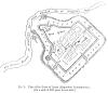
His sketch plan of Arzen:
-
In October, 1861, I made a short journey from Diarbekr to Saert, by Miafarkeyn, Arzen, and Zok; and from thence, following the course of the Bohtan Su, or Centritis, to Til, where it joins the Tigris, whose course I followed close up to Redhwan, on the Arzen Su. Crossing this latter river, I proceeded to Hesn Keyf, on the Tigris, and then, via Mediat and Mardin, back to Diarbekr. (I've left out the rest of the text until he reaches Arzen.) Four hours and a half from this (an old bridge over the Batman Su) I crossed the Iluzu Arzen, or Redhwan Su - it is called by all these names - into the present district of Gharzan. The province in which it is situated was called Arzanene by the Romans, and Artzn (Moses of Chorene), Aghdsnik, Aghdsen, and Khordsen by Armenian writers, and Arzen by the Arabs, since corrupted into its present name of Gharzan by the Kurds and Turks. It was one of the provinces taken by the Parthians from the Armenians, and was ceded A.D. 298 with Intilene, Zabdicene, Moxoene, and Cordouene, by Narses King of Persia to the Romans, under Galerius, in the time of Diocletian. The ford was near the flourishing village of Giri Hassan, close to the ruins of Arzen, the Oppidum Arzanenorum of Procopius, situated on the left bank of the river. The ruins are very extensive; the remains of the old walls, 20 feet thick at the base, and tapering up to 8 foot, constructed of irregular pieces of rough stone, cemented with mortar, that surround the town are easily traced; and the defences towards the river, consisting of thicker walls and a number of small-domed buildings, are in still better preservation. The area contained within them is about 2700 square yards. On the north-eastern and southern sides the walls are straight and regular, but towards the west it narrows off into an irregular shape that follows the course of the stream. It has four gates, one in each of the three regular walls, and a fourth leading to the river. At the southern side is a mound of ruin connected with the wall, that seems to have been a large fortified bastion. The whole ruin is surrounded by a deep ditch, which was crossed at three of the gates by as many bridges, whose foundations still appear above ground. When I visited it, the area included within the walls was bearing a fine crop of wheat, but the regular lines of the streets, and some of the sites of the larger buildings, could still be traced. So many medals in gold and silver are found here that the fellahs who till the ground are paid nothing by the owner for their labour, and they give him in addition half of everything they may find. The town was built on what appears a natural platform of some little elevation, which, at its western end, has a steep sharp fall into the plain about a mile from the walls, where it is bounded by a deep bed, through which a small marshy stream flows towards the Tigris, close under the Yezid village of Tellebeea, or Tileeba. Independently of other associations, Arzen is interesting as being connected with the earliest Christian history, it having been visited, according to Abul Furraj, the Syrian historian, by Mar Addaeus, or Thaddeus, one of the Seventy, the apostle of the Syrian Chaldaeans (and the same who cured Abgarus Uchama of his leprosy), in the thirtieth year of Our Saviour's Ascension, and the fifteenth of Tiberius Caesar, who then built a church here, which was afterwards called by his name. Higher up the river, and on the same side as Arzen, are the remains of another large city, where I found some of the earliest records of the Moslem conquest, in the shape of tombstones, bearing Cufic inscriptions in the character peculiar to the first century of their era. Many of them are now used by the Armenians of Kani Masee, a small village situated at one end of the ruins, as gravestones. As neither they nor the Moslems knew anything of the characters on them, I thought it best to leave them in their ignorance, as without doubt the latter would soon have desecrated every grave in the place did they know that on each stone the formula of their faith, together with a verse from the Koran, were engraved. Opposite the ruins, on the right bank of the Arzen Su, which was formerly spanned at this part by a fine stone bridge, whose foundations peer above the stream, is the fine old ruin known now by the names of Kalla Sheikh Baj and Kalla Anushirvan. It is situated on a high hill of conglomerate, the usual rock formation here, having at its summit a circumference of l 1/2 mile. The remains are evidently Parthian, and consist of walls of common limestone, 14 feet thick, which in some places is composed of brickwork of thin broad tiles of the same solidity. A couple of families of decayed Gharzan Begs inhabited some miserable huts among the ruins, and they had cleared several of the old houses, which served them for a stable. These were all of course now under ground, the debris of centuries having accumulated over and covered them. They were built in arches in a very substantial manner, and seemed at one time to have occupied the whole surface, as, in several pits that had been dug in different places, the portions of many other similar buildings were also discernible. On all sides but one the mound in nothing but a steep high cliff, commanding a line uninterrupted view for many miles all round; but towards the west a winding and difficult path conducts the traveller to a large gateway still intact, and the only one in the ruin. A few greybeards of the place, who pretended to some traditional knowledge, informed me that the castle, during the times of ignorance - that is, before Islamism - belonged to the Beni Sassan; and stated that the Gharzan Begs, who live at Zok, 4 miles off, were the descendants of that dynasty in these parts; a fact that was corroborated to me by the Begs themselves on a subsequent visit I paid them. Near this is the mountainous district of Sassoon, inhabited by a warlike, unruly set of Kurds, called Baliki; they are neither Moslems, Christians, nor real Kizzilbash. They swear by a church, and never by a mosque, or the Deity, or any of the prophets. In a footnote: The city of Arzen at the time of the Arab conquest was the property of the Armenian lord of Bitlis, and was ceded by him to Iyadh Ebn Ghanem, Omer's general. It subsequently fell, on the decline of the Abbasides, into the hands of the Kurd Merwanides, from whom it passed to a local family. Abul Feda says, "El Melik el Mudhuffer Ghazi, son of El Adel (brother of Saladin), took Arzen of Diarbekr from its lord, Hissam ed Deen, of the ancient family of El Ahdeb, who had possessed it from Melik Shah's time, and gave him Heyni in exchange, A. H. 627," El Mudhuffer was at that time lord of Miafarkeyn.
-
Arpa wrote "...one would get the impression that Diayarbakir and Tigranakert are the same. There is a sizable diasporan community that idetify themselves as Dikrangerdtsi/Tigranakert-tsi and leave the impression that they are in fact from Tigranakert. Amid and Tigranakert were never the same. However there may be a valid reason why they do that. When Tigranakert (built by Tigran the Great) was finally destroyed many of its inhabitants were absorbed into the region of Diyarbakir, they not only brought the name with them they also continued to speak with the distinct dialect of Tigranakert. Many still do. The reason why I said "slight" misconception. There is very little about Tigranakert except that it was located several tens of miles NW of Diyarbakir, best estimation is that it may have been where the Turkish town of Silvan is now. In fact it is said that several years ago the ruins could still be seen there." The original Tigranakert is probably (almost certainly) a site known as Arzen, a long way east of Diyarbekir. Amazingly, the only proper description of the place was published way back in in 1865 (Taylor - Journal of the Geographical Society, vol35, 1865). Here is that description. I will post more recent writings about the site later, if I am not banned again.